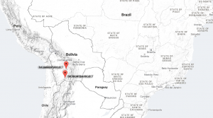
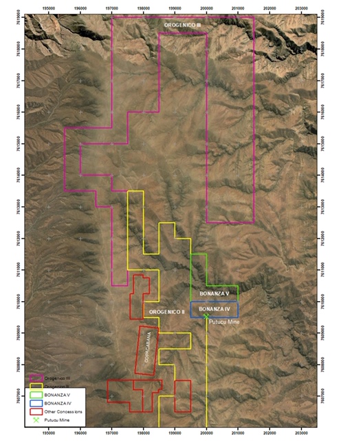
Orogenico and Bonanza properties Southern Bolivia
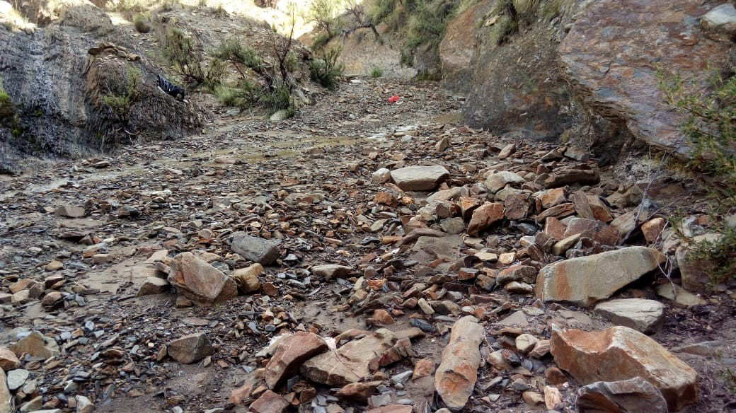
Colluviums
Deposits of unsorted to very poorly sorted gravel, sand, silt and clay are present on the margins of some of the valley alluvial gravels up against the bed-rock valley walls. This unit includes mixed alluvium and debris flow material as end members. It may possess layers of water-washed detritus, but it is largely composed of boulder- to clay-size material that has accumulated by gravity movements and water flows near the foot of gently to steep slopes; boulders are generally angular to subangular in shape. Vegetative organic matter is frequently incorporated in the unit.
Several of these deposits contain gold (lead and zinc) placers, and they have been or are being mined. Much of the placer gravel in the creeks is colluvium. Most of the creeks are narrow, with gently sloping to steep valley walls, and is an ideal environment for the generation of gravity-induced detrital deposits.
The smooth, gentle slopes on the east side of the properties are also mantled with colluvium. These deposits have been mined where they crop out on the valley flood plain. Farther back, the colluvium is also gold (lead and zinc) bearing. Areas of colluvium bordering the lower stretches of the creeks have been mined at various times and have produced mainly gold. Values are not known but usually are found in the panned concentrates as large nuggets of lead and zinc up to 4 cm in diameter and gold flakes up to 5mm in size. Minable deposits of locally occurring gold-bearing alluvium and colluvium, are present along the margins of other steep-sided, narrow placer-rich valleys.
Where gold, lead and zinc are found in colluviums in minable amounts, gold, lead and zinc-rich alluvial deposits were probably somehow incorporated in the mass-wasted deposit during downslope movement. The rich bench gravels along the valley sides are probably at least a partial source of the gold, lead and zinc in the colluviums within the Orogenico and Bonanza properties.
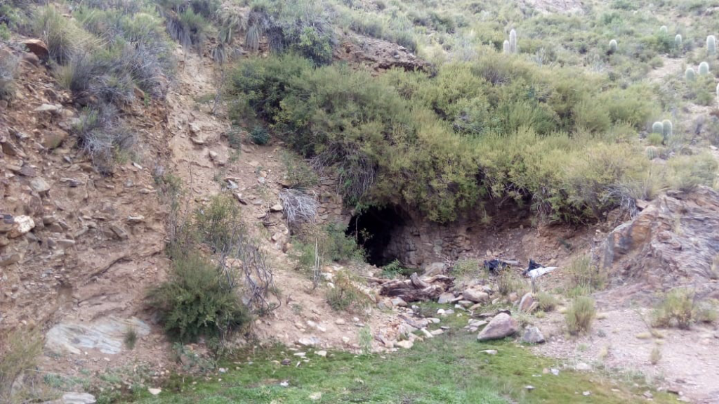
The Putucu mine
Within the district an abandoned gold mine called Putucu was found, which dates from the Spanish colonial era, and that is sporadically mined by local community members. Ruins of an old camp are seen, where probably more than 100 people resided when the mine was active. It presents more than 300 meters of underground galleries and the host rock is colluvium. The extension of deposit ranges as approximately 150 m in length, 60 meters in width and 40 m in thickness.
Fan Gravel
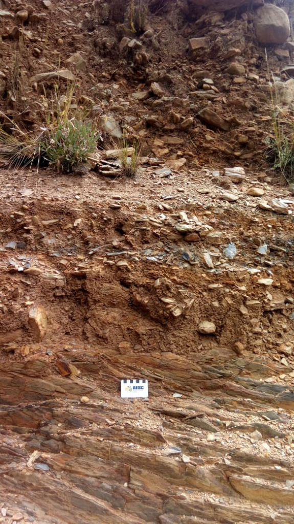
This unit refers to those alluvial and colluvial deposits of Quaternary age. Poorly sorted gravel of both colluvial and alluvial origin is common in the district and as small scattered exposures in narrow relatively steep-sided valleys. The locally derived gravel is grayish brown and composed of boulders, cobbles, sand, silt, and clay; boulders as much as 0.5 m in diameter are rare, and the more common size is 10 to 20 cm in diameter. Most of these deposits are gold (lead and zinc) bearing.
The gold deposits of fan gravel were derived from mines such as Copacabana, located to the west of the properties map and other gold bearing veins to the N, NW and NE, and the lithologies of clasts making up the fans reflect the proximity to these different source areas. The probable gold source rocks on the east give rise to the gold-rich fan deposits.
Quaternary Gravel
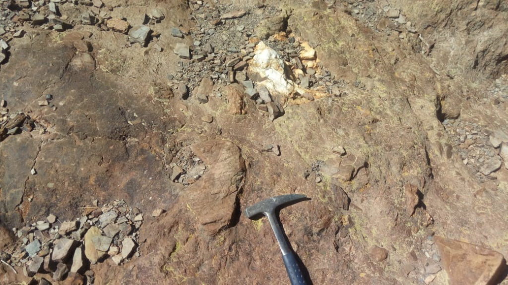
The clasts within the Quaternary gravel are primarily sandstone, siltstone, shale, hematite and quartz. That all but the quartz clasts are decomposed indicates hydrothermal alteration may have occurred. The unit shows little or no sorting, is high in clay owing to the breakdown of original feldspathic minerals, and is frequently stained yellow to orange-red by the decomposition of ferromagnesian minerals from within the clasts. The alteration does not seem to lessen with depth; however, no more than 3 m of vertical exposure was observed. Thickness of the gravel is not known.
A poor to moderately consolidated conglomerate and sandstone unit, exposed on the tributaries, for hogbacks paralleling the northeast strike and appears to dip as much as 55° SE. Several small flakes of gold were panned from this unit. These rocks are gravels with well-rounded clasts of sandstones, siltstones and shales within a clay-rich matrix.
Gold (lead and zinc)-Bearing Alluvial Gravel
Gold-bearing gravel is present throughout the district as both contemporary fIood-plain and older terrace deposits along the valley margins. Included within this gravel are thin lenses, beds, and horizons of sand, silt and clay.
Alluvium
The fluviatile gold placer deposit stretches along 1-30 km of the primary gold deposits, especially the Copacabana mine. The valley alluvium ranges up to 10 m wide and averages 4 m in thickness. The basal gold-bearing comprises bimodal channel lag pebble-gravels with the gold especially concentrated immediately above the bedrock. The detrital gold is medium coarse sand size, moderately sorted, and occurs as scaly flakes and platy nuggets. Concentration of gold was especially favored in two depositional environments. In the slope interruption zones at the confluence of the streams, coarse platy gold was deposited while the finer gold was able to be entrapped further downstream above irregular sandstone bedrock surfaces.

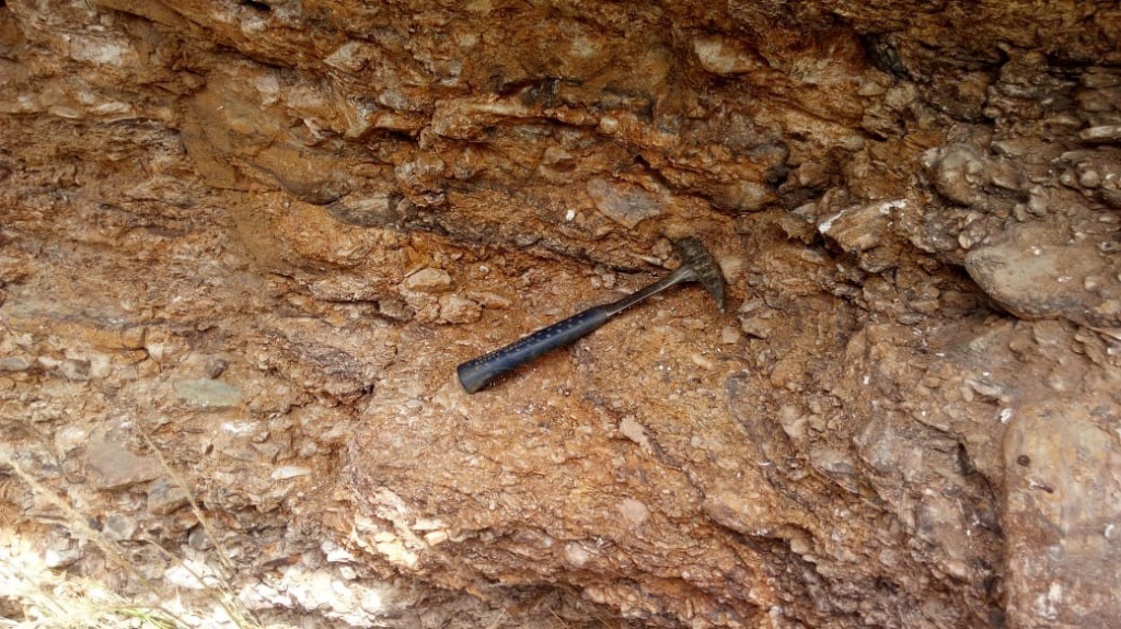
Ferricretes
At the Orogenico and Bonanza properties, the sediments are partially capped with 2–5 m of ferricrete (Fe oxide-cemented sediment). The principal constituents of these units are goethite, hematite and quartz. The ferricrete residuum may host exploitable secondary gold deposits, which overlie weathered and fresh primary mineralization. Understanding the mechanisms of enrichment of Au and pathfinder elements in ferricrete will assist future discovery. Three types of Au sources in ferricrete Au deposits. In Type 1, most Au is sourced from the underlying mineralization. In Type 2, Au is sourced from both underlying and external mineralization. In Type 3, all Au is sourced from external mineralization.
Preliminary Gold Resource Estimate
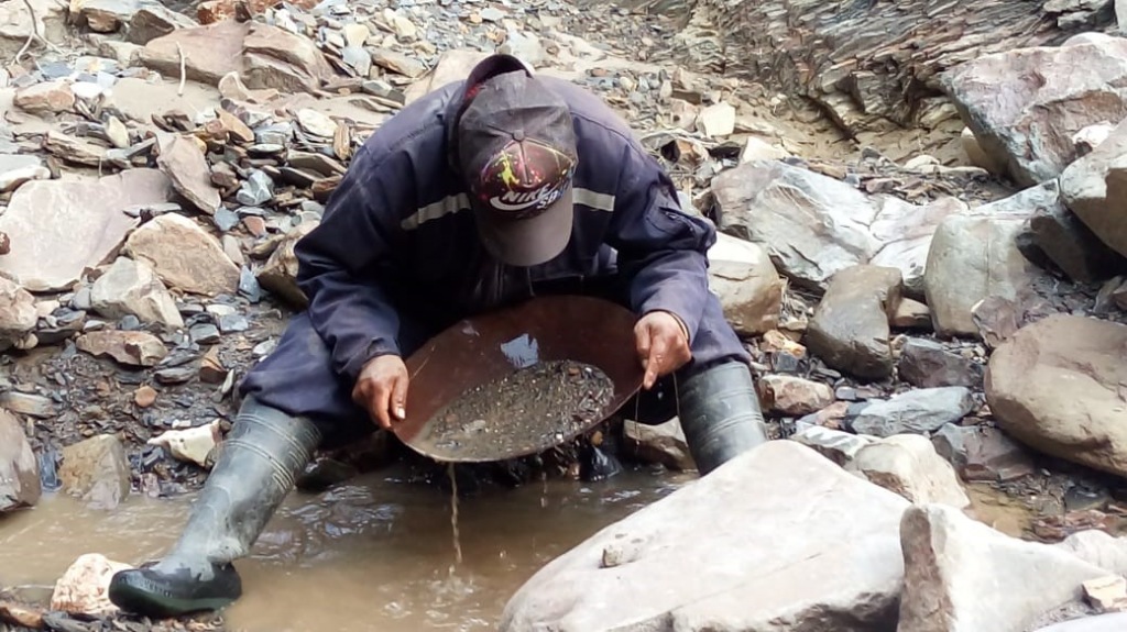
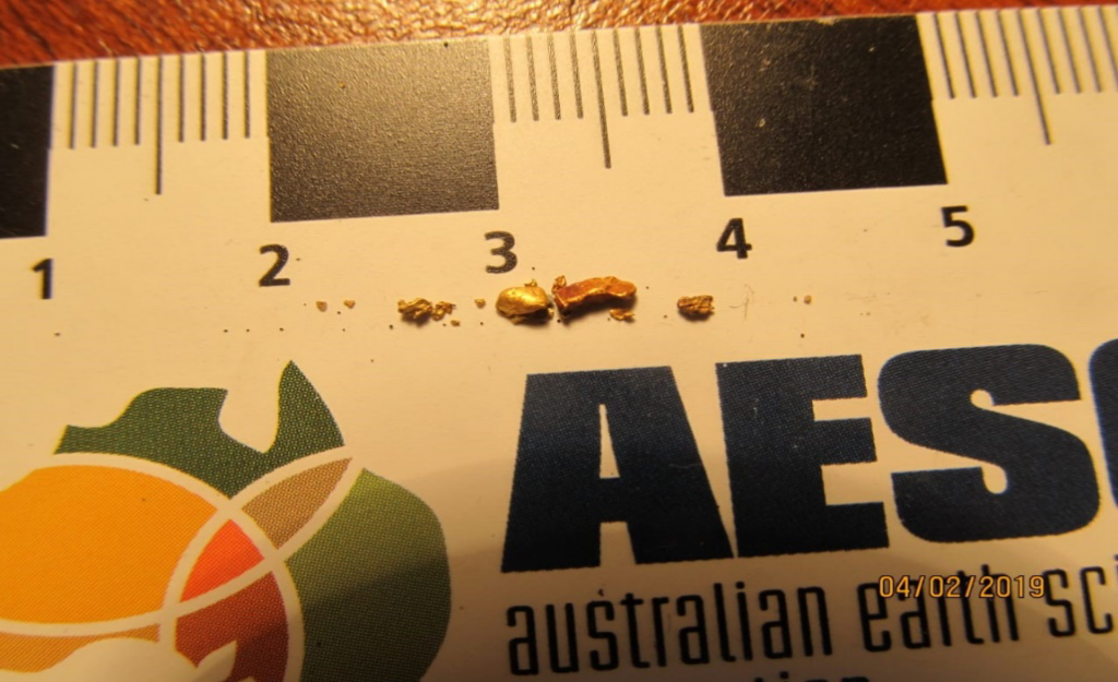
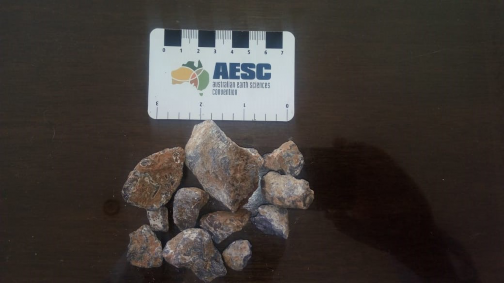
Gold has been recovered by panning colluvium material from the hillsides and alluviums along river beds. In the colluviums, within 5-20 m of a source bed of gravel-rich colluvium, 25 kilos of “dirt” were collected, which yielded fines and some coarse gold weighing 0.249 g. In the river bed, 10 kilos of alluvial material returned 0.15 g Au and 360 g of dominant galena and minor sphalerite.
Therefore, an average gold in selected samples revealed an approximate grade of 10 g/Au tonne, however, an average grade in the colluviums/alluviums can be estimated at 2.5-3 g/Au tonne. The estimated tonnage of the colluvium-alluvium material could reach 10 – 15 million tonnes, therefore these materials may contain at least about 1 million ounces of gold.
Additionally, many hundreds or thousands of tonnes of galena and sphalerite can be recovered from these secondary deposits.
Depth of formation and pressure of trapping of FI
The formation temperature estimated from fluid inclusion (FI) microthermometry can be used to infer formation depth of veins using the boiling point curve of Hass, 1971. The formation temperature of each vein is plot on the temperature axis and the salinity value is plot on the curves of salinity (Fig. 1).
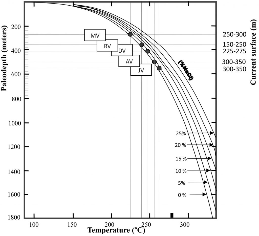
Figure 1: Homogenization temperatures (Th) – salinity diagram illustrating typical ranges for inclusions from different deposit types. Note that fields should not be considered definitive and compositions exist outside the ranges shown (Source: Wilkinson, 2001).
Regarding fluid inclusion studies on orogenic gold deposits in Bolivia, the forming temperatures range from 200-250 centigrades and salinities varying from fresh water to about 5% wt. % NaCl.
According to plots of homogenization temperatures (Th) and Salinity values, estimated depths of formation for orogenic deposits, including the Copacabana vein, Orogenic vein and Bonanza vein, located in the Bolivian Eastern Cordillera of Andes are about 1,000 m.
This result implies an erosion rate of 9 +/- 5 mm yr (-1) assuming that 90% of a single landslide reaches the river on average (Blodgett and Isacks, 2007).
References
- Blodgett, T.; Isacks B. (2007) Landslide Erosion Rate in the Eastern Cordillera of Northern Bolivia. Earth Interactions 11(19).
- Haas, J.L. (1971) The Effect of Salinity on the Maximum Thermal Gradient of a Hydrothermal System at Hydrostatic Pressure, Economic Geology 66: 940–946.
- Wilkinson, J.J. (2001) Fluid inclusions in hydrothermal ore deposits. Lithos 55: 229–272.
Project Map